
San Diego’s Rainy Season Unveiled Through Elfin Forest Data
San Diego weather has a reputation for playing it cool—sunny skies, mild afternoons, and that familiar “we’ll deal with rain later” attitude. Then, every so often, the region flips the script. A run of storms rolls in, the hills turn green, gutters start gurgling, and everyone suddenly remembers where they put the umbrella (usually in the boot, still in its plastic sleeve).
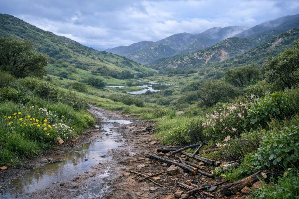
In this post, I’m using a detailed set of rainfall notes from the western side of Elfin Forest—an inland community in North County San Diego, roughly between Encinitas and Escondido, at around 777 feet of elevation. The measurements come from an individual’s personal rain-gauge log, with nearby National Weather Service (NWS) station reports used for comparison. I’ll walk you through what fell, when it fell, and how those totals differed across the county—especially between the coast and the higher inland and mountain areas.
If you live in San Diego County (or you’re planning a move, a build, a landscape project, or even a hiking season), this kind of grounded, station-by-station look helps you understand what “a wet winter” actually means here. I’ve also added practical takeaways, because rainfall totals are interesting, but what you do with them is where life gets easier.
What This Dataset Covers (and Why Elfin Forest Is a Useful Reference Point)
The notes span spring 2025 through February 2026, with the most detailed focus on the late-2025 to early-2026 period. Elfin Forest sits in a spot that’s especially handy for interpreting North County rainfall:
- It’s inland enough to catch stronger storm totals than many coastal blocks.
- It’s low enough in elevation that it doesn’t behave like the mountains (where totals can jump dramatically and snow enters the picture).
- It sits close to a common “gradient zone” in San Diego County: totals often rise as you move inland and up.
When I look at rainfall patterns here, I treat Elfin Forest as a kind of “middle truth”—not as dry as some coastal pockets, not as soaked as Julian and other higher terrain. If you’ve ever compared your own backyard gauge to a friend’s readings a few miles away and wondered whether one of you is cursed, you already know how local this can get.
A quick note on sources and caution
The Elfin Forest totals come from a personal gauge log (a real strength for detail and timing), while the station comparisons reference NWS reporting from nearby locations. Since microclimates vary and gauges differ, you should treat exact numbers as good indicators, not absolute truth for every street. Still, the pattern—when storms arrived, how they stacked up, and where the heaviest pockets landed—comes through clearly.
February 2026: Three Storms That Finally Felt Like “Winter”
February 2026 delivered a sequence of three storms that, together, built a meaningful monthly punch. In Elfin Forest, the three events added up to 2.48 inches of rain.
In San Diego terms, that’s enough to:
- Push noticeable greening across open land.
- Trigger short-lived runoff and pooling in low spots.
- Make you re-check your roof, drains, and any “temporary” fixes you’ve been ignoring since last year.
Storm 1 (around 16 February): A steady start with a windy edge
The first storm arrived with light rain late morning, then strengthened with a frontal passage mid-afternoon. Wind gusts reportedly reached about 46 mph. That matters because wind changes the way rain behaves: it drives water under overhangs, pushes it sideways into vents, and finds the one window frame you forgot to reseal.
Storm 2 (around 18 February): Overnight wind, heavier pockets, and bigger regional spread
The second storm hit overnight with stronger wind notes—gusts reported at 44 mph around 2:30 a.m. and up to 54 mph around 4:10 a.m. Elfin Forest recorded 0.44 inches from this event, and the combined total from the first two storms reached 1.89 inches.
The regional comparisons show how uneven San Diego County can be in a single window. Reports cited totals such as:
- Oceanside: 0.79″
- Rancho Bernardo: 1.88″
- Poway: 2.08″
- Ramona: 2.61″
- Julian: 4.78″ (including 1.62″ in the second storm)
That Julian number does what Julian often does: it politely reminds the rest of us that higher terrain can rack up totals at a different scale. The notes also mention major snowfall in the San Bernardino Mountains (outside San Diego County), on the order of 2–3 feet during the broader system—useful context for how cold and moisture-laden the pattern was.
Storm 3 (around 20 February): A final push to close the sequence
The third storm arrived on the afternoon of 20 February, with a noted gust around 36 mph near 4 p.m. It added 0.59 inches in Elfin Forest. That brought the three-storm February sequence to 2.48 inches.
From my own experience watching San Diego winters, this is the classic “stacked storms” effect: one event is interesting, two make the soil respond, and three in close succession change the look and feel of the landscape.
January 2026: Drizzle, Fog, and Small Totals That Still Add Up
January didn’t roar. It murmured—foggy nights, light showers, brief gusts, and those days where the sky can’t decide whether it’s British or Californian. Still, for gardens, slopes, and groundwater, smaller events matter, especially when soils start the season dry.
Several small entries stand out:
- 2 January: light drizzle adding about 0.07″
- 3 January: fog and showers adding about 0.05″
- 4 January: a mix of very light rain and a brief heavier burst; mentions include 0.10″ plus an earlier 0.20″
- 5 January: overnight rain around 0.49″, with a two-day total of 0.59″
The notes describe a January total around 1.82 inches (with a correction noted as of 1 February), plus that specific two-day run at 0.59 inches. If you’ve lived here for a while, you know that January can go either way: sometimes it’s a big month, sometimes it’s a “bitty rain” month. This version leaned toward frequent small doses rather than one dramatic downpour.
Why small January events still matter in San Diego
Even when storms feel mild, they can:
- Reduce wildfire risk later by supporting winter vegetation growth (with the usual caveat: growth becomes fuel if spring dries out fast).
- Improve soil moisture so that later storms produce less immediate runoff and more infiltration.
- Expose drainage problems in a gentler way—so you can fix them before a heavier system arrives.
I’ve found that a “soft” rainy month often gives homeowners the chance to catch issues early. When you spot a slow leak during a drizzle, you’ve got time. When you discover it during a wind-driven downpour at 3 a.m., you’ve got a bucket and a bad mood.
December 2025 and the Late-Autumn Ramp-Up: When the Season Started Feeling Real
San Diego’s rainy season often arrives in fits and starts. December 2025 included a notable Christmas Eve event, plus another late-December rainfall.
24 December: Christmas Eve rain with heavier bursts
On 24 December, the notes describe a band of rain arriving in the afternoon with heavier bursts, producing about 0.65 inches for the storm total in Elfin Forest. There were also mentions of much higher totals in parts of Los Angeles and nearby mountains—context that aligns with the idea of a regional system with stronger impacts north and at elevation.
27 December: A lighter follow-up
On 27 December, a nighttime light rain with occasional stronger showers added around 0.29 inches.
These late-December events matter because they help set the seasonal baseline. If December delivers meaningful moisture, January and February storms interact with soils differently than they would after a bone-dry autumn.
November 2025: A Cluster of Storms and the Reality of Missed Forecast Totals
November is where San Diego rainfall stories often begin. You get the first proper systems, people get oddly excited about cloud layers, and weather apps become everyone’s favourite form of entertainment.
The notes describe November as active, with multiple storm periods:
- 15–16 November: heavy rain pushing totals to around 1.38″ by late afternoon on the 15th, then about 1.54″ by the morning of the 16th (with trace amounts after).
- 18–19 November: rain from evening into the morning totalling about 0.66″, then morning showers bringing it to about 0.73″.
- 20–23 November: a third storm starting on the 20th afternoon (around 0.12″), with a small add-on by the 23rd morning (around 0.02″), producing about 0.46″ for that storm period.
One detail I appreciate here: the notes mention a forecast expectation of about an inch on the coast for that late-November event, but observed amounts came in lower in at least one area. That’s extremely San Diego. Forecasting here involves coastal influence, terrain, storm track, and timing, and a subtle shift can change totals a lot.
What I take from November 2025
Three themes show up plainly:
- Storm clustering: multiple systems can arrive in a narrow window, even if the rest of the month stays quiet.
- Local variability: a “county forecast” doesn’t tell you what your street will get.
- Expectations management: observed totals often land below the most optimistic model runs—especially near the immediate coast.
Earlier 2025 Episodes: Spring Systems and a Spiky Pattern
The dataset also includes earlier rain entries from 2025, which help confirm that rainfall didn’t simply “start” in late 2025. Instead, the pattern looks typical for Southern California: occasional spring storms, summer quiet, then the autumn return.
February and March 2025: Light events, then a stronger March storm
- 6 February: light rain around 0.02″
- 12 February: light rain and drizzle around 0.13″ (with forecasts mentioned in the range of 0.5–1″ that day and 1–1.5″ the next)
- 7 March: about 1.53″ from a storm described as patchy rather than a clean front
- 11–12 March: around 0.44″ followed by about 0.46″ overnight
The “patchy rain” observation resonates with anyone who’s watched a storm line break up over the county. You can stand outside and see sun in one direction, slate-grey in the other, and your weather app insisting it’s raining everywhere at once.
April and September 2025: Small April showers and inland thunderstorms
- 26 April: totals noted around 0.05″ overnight and up to 0.08″ with afternoon showers
- 3 September: interior thunderstorms with examples like Ramona around 0.30″ and Julian around 0.03″
That September entry is a nice reminder: late-summer convection can produce highly local rain. It may not shift the seasonal totals much, but it can make a trail messy, cool off an evening, or confuse everyone’s plans for an outdoor birthday party.
Regional Comparison: Why Julian Often Leads and the Coast Often Lags
San Diego County’s rainfall gradient is real. In broad strokes, totals tend to rise as you move inland and up in elevation, with coastal zones often receiving less in many storm setups. The notes include a simple comparison table that makes the point clearly for the February 2026 run:
- Elfin Forest (Feb 2026, three storms): 2.48″
- Julian (Feb 2026): 4.78″
- Ramona (Feb 2026): 2.61″
- Poway (Feb 2026): 2.08″
- San Diego (Feb 2026): 1.16″
Even if you don’t obsess over meteorology, those numbers tell a practical story: if you manage property, landscaping, grading, drainage, or outdoor operations, you should not assume the county’s rainfall experience is uniform.
Practical implications for residents and property owners
- Drainage design: inland communities may need to plan for higher short-term runoff volumes during winter clusters.
- Landscape planning: plant choice and irrigation schedules should reflect your real zone, not a general “San Diego is dry” assumption.
- Road and trail conditions: the mountains can shift from rain to snow fast, while coastal areas stay wet but functional.
What These Storm Notes Say About San Diego’s Rainy Season Rhythm
Reading through these entries, I see a rhythm that many locals will recognise:
- Long dry gaps punctuated by active storm windows.
- Wind as a frequent companion, sometimes as memorable as the rain.
- Big differences by location, even within the same general region.
- Mountains and higher inland areas frequently posting the largest totals.
That rhythm shapes behaviour. You postpone a repair because it’s “always sunny”, then you suddenly need it done yesterday. You ignore your yard drainage because it hasn’t mattered for months, then three storms arrive in one week and your side passage becomes a miniature canal.
I’ve lived in places where rain is a daily presence, and I’ve learned that San Diego works differently. Here, water arrives in chapters, not paragraphs. You feel the contrast more sharply—and you remember each significant storm for longer.
Actionable Takeaways: What You Can Do Before the Next Storm Cluster
These totals are historically interesting, sure, but they also point to a sensible checklist. When San Diego gets a run of storms, small weaknesses in your home or operations become very obvious.
Home and property checklist (simple, not fussy)
- Clear gutters and downspouts before the season ramps up. Do it once properly, then check again after wind events.
- Watch where water pools during a light rain. That’s your low-risk “test run” before heavier storms.
- Check slopes and drainage paths around your property, especially in inland areas that can pick up higher totals.
- Inspect window and door seals after the first wind-driven rain; wind finds odd angles.
Outdoor planning: hiking, events, and travel
- Trails change quickly after consecutive storms—mud, erosion, and washed-out sections show up fast.
- Mountains can shift to snow conditions during colder systems; plan with elevation in mind.
- Build buffer days into outdoor events in winter months, especially January–February.
A Brief Detour: The OpenAI “This is not a screenshot” Post and Why It Fits the Theme
The source material you provided also includes an OpenAI social post from April 21, 2026: “This is not a screenshot.” paired with an image link. I can’t verify the image content from the text alone, so I won’t pretend I know exactly what it shows. Still, the phrasing is interesting in the context of weather records.
Rainfall notes often sit in the same category as “not quite official, but incredibly telling.” A personal gauge log doesn’t carry the same status as a formal station network, yet it can capture timing and intensity in a way that broad summaries miss. In other words, a careful field note can be more than a snapshot of a season. It becomes a record of lived conditions—what happened, on the ground, at your elevation, with your wind gusts rattling the windows.
I’m not suggesting we treat informal logs as gospel. I am saying they can be impressively useful—especially when you compare them with nearby station reports and keep your assumptions tidy.
SEO Notes: How to Use This Data in a Local Content Strategy (If You Run a Local Business)
If you operate in San Diego County—landscaping, roofing, drainage, real estate, outdoor recreation, property management—rainfall content can attract highly relevant local search traffic when you write it with care. I’ve done this kind of content work, and I’ve seen the difference between generic “rainy season tips” and posts anchored in local numbers.
Topics that match real search intent
- “How much did it rain in [neighbourhood] this month?” with inland/coastal comparisons.
- Storm prep guides written for North County inland zones vs coastal zones.
- Drainage and runoff explainers tied to multi-storm sequences like February 2026.
- Trail condition updates based on storm clusters and wind impacts.
How I’d structure an effective local rainfall post
- Start with a clear location anchor (e.g., “Elfin Forest at ~777 ft”).
- Include date-stamped totals and a short plain-English interpretation.
- Add nearby comparisons (coast vs inland vs mountains).
- Finish with practical next steps for the reader’s situation.
You’ll notice that this approach respects the reader’s time. It also avoids the worst local-content sin: vague claims with no numbers behind them.
Rain as Relief, Rain as Risk: The Balanced San Diego Reality
The notes describe rainfall as a relief for a typically dry region, and that’s true. Reservoirs and landscapes benefit. At the same time, a wet stretch can bring hazards—especially when wind joins the party or when rain arrives after long dry gaps that harden the soil.
Benefits highlighted by this period
- Landscape greening and a visible shift in vegetation.
- Soil moisture recovery after dry stretches.
- Better reservoir inflow conditions during clustered storms.
Risks that tend to show up
- Wind damage during stronger gust events (the notes cite up to about 54 mph).
- Local flooding and runoff where drainage can’t keep up with back-to-back storms.
- Travel impacts when mountain zones receive heavier precipitation or snow.
If you want one simple rule of thumb, I use this: when storms arrive in a series, treat the third one with more respect than the first. The ground has changed by then, and so has your margin for error.
Closing Thoughts: What I’d Remember from the Elfin Forest Log
If I had to summarise what this Elfin Forest dataset teaches, I’d keep it grounded:
- San Diego rain doesn’t need to be constant to be meaningful.
- A handful of well-timed storms can reshape the season’s feel.
- Inland and higher locations often collect far more than the coast.
- Wind matters—sometimes as much as the rainfall total.
When you read these totals—2.48″ across three February storms in Elfin Forest, nearly 4.78″ for the same window in Julian—you see the county’s personality. It’s not uniform, it’s not predictable in a neat way, and it rarely behaves like a single “city climate.”
If you live here, you already sense that. With data like this, you can plan around it. And frankly, planning around it beats doing the 2 a.m. bucket shuffle any day of the week.