
San Diego Winter 2025/26 Rain and Wind Patterns Detailed
I wrote this piece with one goal in mind: to help you understand what actually happened in San Diego County during winter 2025/26—rain totals, wind peaks, timing, and the way conditions shifted from the coast to the inland valleys and up into the mountains. I’m leaning on a single, consistent set of field notes from a private weather station in the western Elfin Forest area (north county), cross-checked against nearby National Weather Service (NWS) station reports that were referenced alongside those notes.
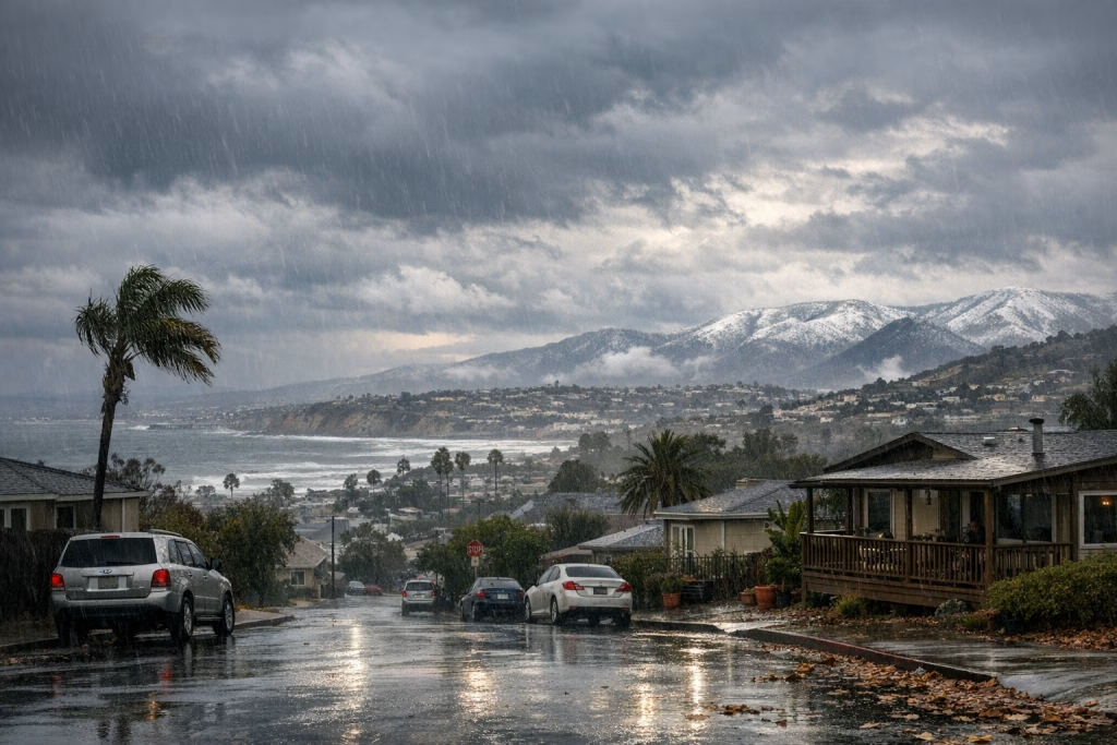
If you live in the region, you already know the broad stereotype: “mild, sunny, not much rain.” Winter 2025/26 did its best to complicate that story. The season included stretches of dryness, then a burst of back-to-back storms that brought meaningful rainfall totals and some properly punchy winds—especially during frontal passages.
Below, I’ll walk you through the season in a practical, SEO-friendly structure: what fell, when it fell, where it fell more, and what the winds were doing while all of that happened.
What this report covers (and how to read the numbers)
Time window and geographic context
The observations in this report span September 2025 through February 2026, with the heart of the story happening in November 2025 through February 2026. The primary measurements come from a personal weather station located in the Elfin Forest area (western side, around 777 feet elevation), positioned roughly between the coastal corridor and inland communities.
To keep the picture grounded, the notes compare those on-site measurements with NWS-reported totals for nearby locations (for example: Oceanside, Carlsbad, Escondido, Poway, Ramona, Julian, and central San Diego). You’ll see a repeating pattern: the farther inland and higher you go, the more totals can jump—especially in places like Julian—while the immediate coast often comes in lighter.
Units and what “storm totals” mean
Rainfall is given in inches (with occasional millimetre approximations). Wind speeds are provided in miles per hour (MPH). “Storm total” refers to the total accumulation attributed to a particular storm period, as described in the notes. When storms arrive in quick succession, totals can stack up fast and blur together, so I’ll flag where the text indicates combined totals across multiple events.
The big picture: a dry autumn, then a busy winter stretch
Autumn 2025 leaned dry overall, then winter delivered several rounds of rain. What stands out most is that the season didn’t behave like a steady, gentle rainy period. It behaved more like Southern California often does: long gaps, then concentrated action.
From the notes, these themes keep coming up:
- Rain arrived in pulses, with a few storms doing most of the heavy lifting.
- Wind peaked around frontal passages, occasionally pushing into the 40–50+ MPH range in exposed spots.
- Location mattered: inland and higher terrain frequently recorded higher totals than the coast.
- Forecast language softened or shifted as systems approached, which is pretty typical when models disagree on exact track and intensity.
February 2026: three storms in a row (the peak of the season)
If you only remember one part of winter 2025/26, make it February. The notes describe three consecutive storms that moved through in close order, producing the most concentrated rainfall stretch of the season along with notable winds.
Storm 1 (around 16 February 2026): a front, rising rain rates, and gusty winds
The first storm in the February series began with light rain late morning (around 11:00), then picked up noticeably by early afternoon (around 14:00) as the front came through. The wind report in the notes mentions gusts up to 46 MPH measured at a local utility weather station (SDG&E is referenced in the original notes).
That “front arrives, winds lift, rain sharpens” sequence is classic. It also tends to be the moment your patio furniture regrets its life choices, so if you live in a wind-prone spot, you know the drill.
Storm 2 (around 18 February 2026): overnight wind and heavier bursts
The second wave arrived quickly and carried a stronger wind signature. The notes describe a windy night paired with heavy rain, with a reported peak gust of 54 MPH around 4:10 AM.
Recorded rainfall for this event at the Elfin Forest station came in at 0.44 inches (about 11 mm). More importantly, the notes state that the first two storms together added up to 1.89 inches at that station, which tells you the series was adding up fast.
The NWS comparison totals cited in the notes for this storm (or this time window) include:
- Oceanside: 0.36″
- Carlsbad: 0.45″
- San Marcos: 0.40″
- Escondido: 0.44″
- Rancho Bernardo: 0.40″
- Poway: 0.57″
- San Diego: 0.41″
- La Mesa: 0.59″
- Ramona: 0.40″
- Julian: 0.95″
That list is useful because it shows the familiar gradient: some coastal and near-coastal totals cluster in the 0.3–0.5″ range, while Julian nearly doubles many coastal values. The notes also mention mountain snowfall in a broader regional context (San Bernardino Mountains receiving feet of snow), which fits the same pattern of elevation amplifying precipitation impacts.
Storm 3 (around 20 February 2026): another half-inch and a solid monthly finish
The third storm brought 0.59 inches at the Elfin Forest station and gusts reaching 36 MPH around 16:00.
Across the three-storm run, the station total reached 2.48 inches. For one concentrated period, that’s a respectable haul for North County coastal-inland transition terrain—enough to make hillsides green up, enough to test storm drains, and enough to turn a commute into a slow crawl if timing lines up badly.
January 2026: a wet start, then quieter intervals
January serves as a reminder that winter didn’t “flip on” and stay on. Instead, it arrived in episodes—some small, some meaningful.
Early January (2–5 January 2026): light events that add up
On 2 January, the notes describe light showers producing 0.07 inches (a drizzle-type event), with a referenced storm total around 1.87″ for that broader storm window in the notes.
On 3 January, fog and light showers added 0.05 inches. On 4 January, morning rainfall reached 0.20 inches from overnight precipitation. Later that day, another burst brought roughly 0.10 inches. The notes also mention forecast wording shifting away from “heavy,” which happens when confidence drops on intensity or when the core dynamics trend weaker.
On 5 January, a nighttime rain event produced 0.49 inches, and the notes combine the two-day total as 0.59 inches across the 4–5 January stretch.
Late January (24 January 2026): a small top-up
By 24 January, the notes record a modest 0.05 inches after a couple of days, reflecting the “on and off” nature of the season. These small events don’t make headlines, but they matter for soil moisture—especially when you string them together between bigger storms.
December 2025: holiday rain with a notable Christmas Eve event
December’s story in the notes centres on a pair of events, including a stronger one on Christmas Eve.
24 December 2025: heavier bursts
On 24 December, the notes describe heavier showers and gusty conditions, with measured rainfall at 0.65 inches (station total). The notes also refer to heavier rainfall further north (including Los Angeles) and larger mountain snow totals in the broader region, which fits a storm track that favours higher terrain and certain coastal ranges.
27 December 2025: a quieter follow-up
On 27 December, overnight rain with stronger showers produced 0.29 inches. This kind of “secondary system” or trailing moisture is common in winter patterns: one storm lays down the main punch, then follow-ups sweep in with lighter totals.
November 2025: the month that started feeling like winter
November 2025 appears in the notes as a more active month than the early autumn period, including a sequence of storms and accumulating totals.
15–16 November 2025: a wetter spell with building totals
On 15 November, the notes describe heavy rain building to a total of 1.38 inches by around 16:00, with earlier accumulation cited around 0.48 inches after mid-morning. By 16 November, overnight showers brought the total up to 1.54 inches.
That’s the sort of weekend where you cancel a hike, make tea, and pretend you’re living in Manchester for the day—until the sun returns and you remember you’re still in San Diego.
18 November 2025: another evening/night rain period
On 18 November, the notes record 0.66 inches during the evening and overnight, then reference a later value around 0.73 inches (as written in the source notes). This suggests either continued accumulation into the next measurement window or a refined total after additional rainfall.
20–23 November 2025: a third storm and a light finish
On 20 November, a third storm started in the afternoon with 0.12 inches recorded early on, with forecasts in the 0.5–0.75 inch range mentioned in the notes. By 23 November, an additional 0.02 inches brought a referenced total of 0.46 inches for that segment, with a note that coastal totals were generally below an inch.
September 2025 and early 2025 context: dry-leaning signals and isolated events
The notes also include a few context points outside the core winter months, and they help explain why the winter rains felt like a relief: preceding periods leaned dry, with occasional isolated events.
September 2025: isolated interior storms
On 3 September 2025, the notes mention interior thunderstorms with an example total around 0.30 inches reported for Ramona, while Julian is cited around 0.03 inches in that particular instance. That’s a nice reminder that convective events can be patchy and weird—two places can sit under the same “chance of storms” umbrella and end up with totally different outcomes.
February and March 2025: small rainfall and a “blob” event
The notes reference small totals in early February 2025 (for example 0.02 inches on 6 February and 0.13 inches on 12 February), then a mid-March period described as an unusual precipitation “blob” producing totals around 0.44–0.46 inches, with nearby NWS totals in a roughly 0.4–0.6 inch band.
I’m including that because it echoes a recurring theme in San Diego weather: sometimes the most memorable events aren’t the biggest storms, but the oddly shaped ones that refuse to behave neatly on radar.
Wind patterns: when the rain comes with a shove
Rain grabs attention, but wind shapes the lived experience: downed branches, power flickers, fences leaning at odd angles, and the general sense that your house is being lightly tested.
Across the winter notes, the standout wind figures include:
- 46 MPH during the 16 February frontal passage window
- 54 MPH during the 18 February overnight storm window
- 36 MPH during the 20 February storm
Those are meaningful gusts for the region, especially when soil is saturated and trees catch more wind load. If you’re planning outdoor work or event operations during winter storm windows, those gust numbers matter as much as rainfall totals do.
Coast vs inland vs mountains: why totals vary so much
The NWS comparisons in the notes repeatedly hint at a simple truth: San Diego County is a patchwork of microclimates. The coast can pick up a modest half-inch while higher inland spots collect nearly an inch in the same system, and mountain areas can add snow and stronger impacts on top.
Elevation and orographic lift
As moist air is forced upward over terrain, it cools and condenses, increasing precipitation. That helps explain why Julian frequently appears as a higher-total leader in the comparisons. Even when coastal locations see decent rain, the mountains can quietly run away with the scoreboard.
Storm track and exposure
Slight shifts in storm track—north, south, closer to the coast, more inland—can change who gets the bigger totals. I’ve watched locals argue about “how much rain we got” as if they’re talking about the same event, while living 12 miles apart. They’re both right, annoyingly.
Forecast notes: changing wording, shifting confidence
The source notes point out forecast adjustments, including a moment where “heavy” language was removed. That’s not a failure; it’s meteorology doing what it does. Models update, the atmosphere evolves, and forecasters tune language to match risk.
If you use forecasts for planning—construction schedules, deliveries, outdoor events—my advice is simple and based on experience: treat early calls as a rough sketch, then make your serious decisions closer to the event window. In San Diego, a small track change can turn your “light showers” into a solid soaking, or the other way around.
Quick reference table: the winter’s notable periods
Here’s a compact summary drawn from the notes. I’m keeping it intentionally tight so you can scan it quickly.
| Period | Notable rainfall in the notes (Elfin Forest station) | Notable wind (MPH) | Consistent higher-total area in comparisons |
|---|---|---|---|
| Nov 2025 | Up to 1.54″ (15–16 Nov sequence) | Not specified in the notes for that period | Julian often higher |
| Dec 2025 | 0.65″ (24 Dec), 0.29″ (27 Dec) | Gusty conditions noted (no single peak given) | Mountains favoured for snow in regional context |
| Jan 2026 | Multi-day stretch with 0.59″ across 4–5 Jan; smaller events later | Not a headline wind month in the notes | Varies |
| Feb 2026 | 2.48″ across three storms (16/18/20 Feb sequence) | 46–54 MPH peaks noted; 36 MPH later | Julian cited at 0.95″ in a comparison list |
Practical takeaways if you live or work in San Diego County
I’m not writing this as an academic exercise. You’ll get more value if you treat it like a planning guide for the next “busy winter” that rolls through.
If you manage property or facilities
- Plan around wind peaks during frontal passages, not just rainfall totals.
- Check drains and gutters before multi-storm sequences; 2–3 storms close together stress systems more than a single big day.
- Remember that coastal totals can understate inland impacts. If you have sites in Poway, Ramona, or mountain-facing zones, verify local conditions.
If you commute (especially across inland corridors)
- Expect the worst driving right around the front’s arrival window—that’s when rain rates and gusts often spike together.
- If you travel toward higher elevations, watch for winter travel impacts during colder systems; the notes mention substantial snow in nearby mountain ranges during the broader pattern.
If you garden, landscape, or track water in the soil
- Those “small” events (0.05″, 0.07″) still matter when they land between bigger storms.
- A February-style series can bring meaningful recharge, but it can also cause runoff issues if the ground can’t absorb fast enough.
About that unrelated “research” text you may have seen
You might notice that the material bundle included a separate section referencing AI automations and a thread-based workflow, plus a social post link. That content doesn’t match the weather dataset or the “San Diego Winter 2025/26” topic, so I’m not using it to shape the meteorological analysis. I’m sticking to the weather notes and the cited comparisons, because mixing topics would muddy the picture and hurt search intent alignment.
SEO phrases you’re likely searching for (and how this article matches them)
I’m including this section because it helps you map your search intent to the content above without stuffing phrases awkwardly.
- San Diego winter rain totals 2025 2026: covered via monthly and storm-period measurements and comparisons.
- San Diego February 2026 storm rainfall: covered via the three-storm series and the 2.48″ total.
- San Diego wind gusts winter storms: covered via 46, 54, and 36 MPH notes tied to storm dates.
- Oceanside vs Carlsbad vs inland rainfall: covered via the comparison list and the coast/inland gradient explanation.
- Julian rainfall higher than coastal San Diego: reflected in the NWS comparison values cited in the notes.
Final notes on reliability and “what to trust”
These measurements come from an enthusiast station with careful note-taking, paired with referenced NWS comparison reports. That’s a sensible way to tell a local weather story, because it gives you both: the on-the-ground reality in one spot, and a broader set of official station totals for context.
If you want to replicate this approach for your own neighbourhood, I’d do what the author of the notes did: keep consistent measurements at home, then compare them to nearby official totals. Over time, you’ll learn your microclimate’s personality—where it overperforms, where it disappoints, and when the wind likes to show off.
And yes, if you’re anything like me, you’ll start remembering storm dates the way other people remember birthdays. That’s probably fine. Probably.