
San Diego Storm Patterns 2025-2026 Insights and Trends
I’ve spent a fair bit of time working with teams who plan campaigns, field events, and sales outreach around real-world conditions. And if you’ve ever tried to run anything on a schedule—site visits, open houses, outdoor activations, even a simple delivery—you’ll know weather has a habit of turning tidy plans into improvisation.
This article pulls together recorded rain and storm notes from 2025–2026 across San Diego County and nearby locations (with several measurements cited around Elfin Forest at roughly 777 feet elevation), then turns them into practical insights. You’ll see how rainfall totals stacked up storm-by-storm, where intensity peaked, and what patterns actually mattered on the ground—wind, timing, and how unevenly these systems hit the region. I’ll also share how I personally translate this kind of timeline into planning and communication, because data is lovely, but decisions are the point.
At a Glance: What 2025–2026 Looked Like for San Diego Storms
The notes show a seasonally familiar setup—wetter late autumn and winter—yet with sharp contrasts between coastal and inland/mountain readings. Several storms came with meaningful wind (often above 40 mph, occasionally above 50 mph), and rainfall frequently varied within short distances.
Here are the headline takeaways I see when I lay the entries side by side:
- Winter 2025–2026 carried the heaviest action, with repeated rain days and a notable three-storm sequence in February 2026.
- Totals were highly local: some inland and mountain-adjacent stations reported multiple inches while others stayed far lower during the same events.
- Wind mattered nearly as much as rain: gusts in the 40–50+ mph range can change risk, travel, and outdoor work far more than a modest rain total suggests.
- Storm “clusters” shaped the lived experience: a run of moderate systems can have more impact than one dramatic day, because the ground never really dries out.
How to Read These Storm Notes Without Fooling Yourself
Before we walk through the chronology, I want to be upfront about something I’ve learned the hard way: rainfall logs can look objective, yet they still mislead if you treat them like a uniform truth for an entire metro area.
Microclimates Turn One “San Diego Storm” Into Five Different Stories
San Diego County spans coastal zones, valleys, foothills, and higher elevations not far away. That means one storm can produce:
- Light coastal showers that barely inconvenience anyone,
- Steady inland rain that soaks soils and fills washes,
- Mountain totals that look like another planet compared with downtown readings.
In the notes, places like Julian and Ramona often show far higher totals than more coastal-adjacent points. I won’t claim any station represents the whole region—and neither should you when you plan around weather.
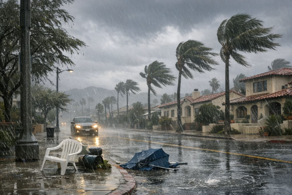
Wind Is the Quiet Co-Star
I’ve seen teams focus on rainfall totals alone and then get caught out when gusts knock over signage, slow roads, or make outdoor work unsafe. Several events here include gusts around 46 mph and 54 mph. Even if the rain number looks “moderate”, those gusts can still disrupt your day.
February 2026: The Three-Storm Sequence That Defined the Season
The standout period in the notes is February 2026: three storms in quick succession. This is the kind of run that changes daily routines—driving, outdoor schedules, and even how cautious people feel about heading out.
Storm 1 (Around 16 February 2026): Front Passage, Building Rain, Strong Gusts
The first storm started as light rain around late morning and strengthened with a frontal passage early afternoon. A recorded gust reached roughly 46 mph. The key detail here isn’t only the rain itself—though it matters—but the timing: midday to afternoon intensification tends to hit when roads are busy and schools, services, and deliveries operate at full pace.
From a practical standpoint, this storm set the tone. When the first system in a series arrives with wind, people remember it. That memory affects behaviour during the next storms, even if the next ones differ.
Storm 2 (Around 18 February 2026): Heavier Rain, Peak Winds, Big Regional Spread
The second storm brought stronger winds—recorded up to about 54 mph near dawn—and heavier rainfall in several locations.
The notes include a local measurement around Elfin Forest of about 0.44 inches from this particular storm, bringing a combined two-storm total to roughly 1.89 inches at that gauge. Nearby station reports show striking variation across the region, including:
- Oceanside: 0.79 inches
- Rancho Bernardo: 1.88 inches
- Poway: 2.08 inches
- Ramona: 2.61 inches
- Julian: 4.78 inches (with about 1.62 inches attributed to this storm in the notes)
That spread matters. If your work (or commute) touches inland corridors, you can’t plan from a single city-centre forecast and expect it to hold.
The notes also mention substantial snowfall in the San Bernardino Mountains, on the order of 2–3 feet. While that’s outside San Diego County itself, it flags a broader system with serious cold-air support—useful context when you think about regional travel, supply routes, or knock-on impacts.
Storm 3 (Around 20 February 2026): Moderate Finish, Still Meaningful
The third storm added about 0.59 inches locally, with winds around 36 mph. It brought the three-storm sequence to about 2.48 inches at the local Elfin Forest-area gauge referenced in the notes.
I see this as the “quiet closer” that still matters because it lands on already-wet ground. In day-to-day life, that influences:
- Runoff and pooling in low spots,
- Muddy access roads and trail conditions,
- Reduced drying time for anything outdoors—construction, landscaping, event setups.
January 2026: Frequent Light-to-Moderate Rain Adds Up
January reads like a month of persistence rather than drama. I’ve always found these months more disruptive than people admit, because repeated “small” raindays create ongoing friction in logistics and schedules.
Early January: A String of Small Totals and One Heavier Night
The notes list several consecutive days:
- 2 January: light showers and drizzle around 0.07 inches, bringing a storm total in the notes to about 1.87 inches
- 3 January: fog and light rain around 0.05 inches
- 4 January: about 0.10 inches in the afternoon, plus an earlier 0.20 inches noted from overnight; a monthly figure in the notes reached about 1.82 inches
- 5 January: roughly 0.49 inches overnight, with the notes describing a two-day combined amount around 0.59 inches
The exact bookkeeping in personal rain logs can vary (storm totals vs day totals vs monthly tallies), but the operational story is clear: repeated precipitation with one more substantial overnight period.
Late January into Early February: A Taper, Not a Full Stop
Later entries mention:
- 24 January: about 0.05 inches
- 6 February: a trace amount
That taper matters because it hints at the ground’s “reset” window before the more intense February sequence. If you’re managing anything outdoors, those breaks are when you squeeze in work. I’ve done that myself—shift tasks forward the moment you see two consecutive dry days, because you may not get a third.
December 2025 and November 2025: Late-Autumn Storm Activity and Local Bursts
Late 2025 includes a mix of heavier days and smaller follow-ups. The notes also indicate that other parts of Southern California experienced very high totals during at least one event, even when the local reading in San Diego County was far lower. That contrast tells you the storm track didn’t spread evenly across the region.
24 December 2025: Christmas Eve Rain Bands With Heavy Bursts
For 24 December, the entry describes bands of rain with heavier bursts and a local total around 0.65 inches. The notes also mention much higher totals elsewhere (including Los Angeles-area and mountain totals reaching very high amounts). I won’t over-interpret those broader claims without station-by-station verification, but the implication is a large system with intense pockets.
From lived experience, storms around holiday dates carry an extra punch: travel increases, people run errands, deliveries spike, and everyone’s patience is already in short supply. Even moderate rain feels worse when the roads are full.
27 December 2025: Another Overnight Event
On 27 December, the notes mention overnight rain and stronger showers, totalling about 0.29 inches. This reads like the sort of “secondary wave” that trails a larger system—less dramatic, still enough to keep soils damp and routines cautious.
November 2025: Three Storms With a Notable Mid-Month Soaker
November stands out as a month with multiple storms:
- 15 November: heavy rain produced about 1.38 inches by late afternoon; a storm total reached roughly 1.54 inches by the morning of 16 November
- 18 November: evening-to-morning rain around 0.66 inches, with showers bringing the figure to about 0.73 inches
- 20 November: began mid-afternoon; about 0.12 inches by evening; later a small addition of about 0.02 inches on 23 November brought the event to roughly 0.46 inches
I pay attention to that 15–16 November period. A mid-month storm delivering over 1.5 inches locally can kick-start the “wet season mindset”—once people see kerbs running and gardens properly watered, they adjust expectations for the weeks ahead.
Earlier 2025: Spring and Late-Summer Notes (Light Events, One Notable March Storm)
The earlier 2025 portion reads like intermittent precipitation rather than a persistent pattern, with one more notable storm in March.
February 2025: Light Events With Modest Totals
Entries include:
- 6 February: about 0.02 inches
- 12 February: light rain and drizzle around 0.13 inches (with forecasts at the time suggesting higher totals for subsequent storms)
Even these small totals matter if you’re tracking soil moisture, fire risk in shoulder seasons, or simply planning outdoor work. I’ve watched teams ignore “minor” drizzle days and then lose half a day to slippery access and slow deliveries.
March 2025: A Storm Total Around 1.53 Inches
A 7 March entry describes a storm closing out at about 1.53 inches, characterised as patchy rather than a clean frontal event. Patchy storms can create the most arguments in planning meetings, because one person’s neighbourhood gets hammered while another stays almost dry. Both think their experience is “the truth”.
11–12 March 2025: Light Additions, Then a Storm Sum Around 0.46 Inches
The notes mention small increments (~0.01 and 0.02 inches) followed by more showers, with a storm sum around 0.46 inches, matching a forecast range of roughly 0.4–0.6 inches.
April 2025 and September 2025: Small April Rain, Inland September Thunder
Two other entries:
- 26 April: about 0.08 inches
- 3 September: inland storms with reported totals such as Ramona around 0.30 inches and Julian about 0.03 inches
That September note signals convective or inland-focused activity where totals can flip expectations. I’ve learned to treat late-summer thunder potentials as “small probability, big inconvenience” events—especially when you’ve scheduled something outdoors and assumed the season stays dry.
Regional Contrasts: Why Julian, Ramona, and Poway Often Look “Wetter”
The notes repeatedly show inland and higher-elevation areas receiving more precipitation than coastal readings. Julian, in particular, appears as a frequent high-total location (for example, the 4.78 inches figure noted during the February 2026 sequence).
There’s no single cause you can pin on one sentence, but in practical terms you can expect:
- Orographic effects to raise totals as air lifts over terrain,
- Storm tracks to favour certain inland corridors,
- Convective bursts to land unevenly, especially outside classic winter fronts.
If you live closer to the coast, it’s easy to underestimate what’s happening 20–40 miles inland. I’ve done that myself—then I’ve driven into a wall of rain that didn’t exist at breakfast.
Wind and Timing: The Two Factors People Underestimate
Rain totals fit neatly into a table. Wind and timing do not, yet they determine whether a day feels manageable or chaotic.
Winds in the 40–50+ mph Range Change Risk Profiles
Several entries cite gusts around 46 mph and 54 mph. At those levels, you start seeing:
- Greater hazard from falling branches and loose debris,
- Harder driving, especially for high-profile vehicles,
- Outdoor setups (signage, tents, lightweight staging) becoming unsafe.
If you’re planning any on-site activity, I’d honestly treat a wind forecast as an equal partner to rainfall totals.
Overnight vs Midday Rain Feels Different in Real Life
Several events peaked overnight or near dawn. That changes how people respond. Overnight rain:
- Leaves roads wet and visibility poor during the morning commute,
- Can create surprise pooling because few people witness the downpour,
- Often triggers “day-after” disruption even when the sky clears.
Midday intensification is different: it collides with active schedules and tends to cause immediate cancellations.
Patterns You Can Actually Use: Planning, Operations, and Communication
You might read this for curiosity—and fair enough. But if you want to use it, here’s how I translate storm timelines into actions. This is the part I bring into my own work when I’m coordinating schedules, media plans, or sales activity around local conditions.
1) Plan for Clusters, Not Single Days
The February 2026 sequence is the perfect example. Three storms in quick succession produced cumulative impacts even when each storm alone might look “manageable”.
- Operational tip: schedule outdoor-critical work for the first clear window after a cluster, not the last clear day before it. The “before” day often disappears to prep, traffic, and last-minute changes.
2) Use Location-Specific Messaging
When inland totals run 2–4 inches and coastal totals stay under an inch, one generic update annoys everyone. Inland audiences feel dismissed; coastal audiences feel you’re exaggerating.
- Communication tip: segment alerts and updates by area (coast vs inland vs foothills). Even a simple split can reduce confusion.
3) Treat Wind as a Separate Constraint
Wind shows up repeatedly in these notes, and it should drive separate decisions: safety, travel, equipment, staffing, and timing.
- Scheduling tip: if gusts rise above ~40 mph, revise outdoor activities even if the rain forecast looks modest. You’ll avoid the “rain wasn’t that bad, but everything still went wrong” day.
4) Track “Ground Saturation” in Plain Language
I don’t overcomplicate this. If you’ve had repeated rain days, the ground stays primed for runoff and mud. That influences parking, access for service vehicles, and outdoor foot traffic.
- Field tip: if two rain events land within 72 hours, assume soft ground and slower logistics the following day, even with sun.
SEO-Friendly Storm Timeline (2025–2026) You Can Reference
If you want a quick reference for the major logged points discussed above, here it is in one place. I’m keeping it tight so you can scan it.
- Nov 15–16, 2025: heavy rainfall; local storm total ~1.54 inches (1.38 inches by late afternoon on the 15th)
- Nov 18, 2025: ~0.73 inches with additional showers
- Nov 20–23, 2025: event total ~0.46 inches (0.12 early, +0.02 later)
- Dec 24, 2025: ~0.65 inches, rain bands and heavier bursts
- Dec 27, 2025: ~0.29 inches overnight
- Jan 2–5, 2026: repeated light-to-moderate rain; includes ~0.49 inches overnight on the 5th
- Jan 24, 2026: ~0.05 inches
- Feb 16, 2026: storm with frontal timing; gusts ~46 mph
- Feb 18, 2026: heavier storm; gusts ~54 mph; strong regional spread (Julian noted as high)
- Feb 20, 2026: ~0.59 inches; gusts ~36 mph; three-storm local sequence total ~2.48 inches
- Mar 7, 2025: storm total ~1.53 inches, described as patchy
- Mar 11–12, 2025: storm sum ~0.46 inches
- Apr 26, 2025: ~0.08 inches
- Sep 3, 2025: inland storms; Ramona ~0.30 inches; Julian ~0.03 inches
What These Patterns Suggest for 2026 Planning (Without Overpromising)
I won’t pretend a single two-year log predicts the future. Weather laughs at that sort of confidence. Still, these notes support a few sensible expectations:
- Expect uneven distribution in any winter system: inland and higher elevations can see much higher totals.
- Expect multi-storm sequences to deliver the bigger real-life disruption compared with a single event.
- Watch overnight wind and rain as a warning sign for rough morning conditions, even if the day later looks fine.
If you want to use this in your own planning, I’d keep a simple rule: you don’t need perfect prediction—you need earlier, clearer decisions. In my experience, that’s what keeps people safe and keeps plans credible.
A Practical Note From My Work: Turning Weather Into Better Marketing Ops
I’m writing this for a weather-focused title, yet I can’t help seeing the operational angle. In Marketing-Ekspercki, we often build automation workflows for marketing and sales teams, and weather is one of those external signals that can genuinely improve timing and relevance.
If you run local campaigns in San Diego County, storm patterns can influence:
- Event turnout and lead quality (fewer walk-ins, higher no-show risk)
- Sales outreach timing (messages land differently on a chaotic commute day)
- Service scheduling (field teams, consults, site assessments)
- Regional segmentation (coast vs inland messaging, especially during uneven storms)
When I’ve implemented simple “weather-aware” adjustments—nothing fancy, just sensible triggers—teams often see fewer wasted touches and a calmer ops rhythm. You don’t need to over-engineer it. You just need to respect that a wet, windy morning changes what people do and how they respond.
Conclusion: The Story of 2025–2026 Is Variability, Clusters, and Wind
The 2025–2026 storm notes paint a clear picture: San Diego’s weather may carry a dry-season reputation, yet the region can swing into meaningful wet spells, especially in late autumn and winter. The February 2026 three-storm sequence stands out for cumulative rainfall and repeated windy conditions, and the regional contrast—especially higher totals reported in inland and elevated areas—shows why one number on a forecast rarely tells your full story.
If you take one thing from this, take this: plan locally, communicate locally, and treat wind seriously. I’ve watched teams save time and money by doing those three things, and you can do it too—without turning your calendar into a meteorology thesis.